A Revolution in Mapping Literacy? Land Plans and Ordinary Cartography (France and the Habsburg Monarchy, 18th–first half of the 19th century)
Using mobile mapping apps every day has become second nature. Thanks to these apps, anyone can now find their way around or anywhere in the world. They are a testament to the high level of mapping literacy achieved by today’s society — in other words, the widespread ability to read a map. This is true at all scales, from the representation of small areas to globes. As drawing maps is closer to everyday experience, it is considered an accessible exercise, rightly or wrongly. Conversely, the production of small-scale maps is still considered a specialist task requiring professional training. Cartographic language, from sketching a plan to participatory cartography, is now accessible to everyone – not just surveyors or geomatics engineers. This historical process is still poorly understood. Despite being disseminated in the public sphere and used in diverse social contexts, large-scale maps have remained in the shadow of small-scale maps in the history of cartography. They were considered less valuable, less prestigious and less intellectually and scientifically demanding.
The history of mapping literacy, particularly with regard to large-scale maps, remains to be written. However, several major historical phases and turning points can be identified. These include the rare and costly use of ‘figures’ and ‘views’ drawn by painters to settle land disputes and enhance the reputation of their patrons from the 14th to the 16th century; the advent of measurement-based mapping in the 17th century, supported by the work of engineers and surveyors; and the exponential growth in the use of maps in response to widespread social demand in the mid-18th century. Other turning points include the homogeneous and comprehensive map coverage of national territories thanks to state mapping efforts in the military (Ordnance Survey 1801, Franziszeische Landesaufnahme 1807, Carte d’État Major 1828) and fiscal field (Napoleonic cadastre 1812, Franziszeisches Kataster 1818, Tithe Maps 1836) fields: these were completed in the 1860s. The popularisation of maps produced by state mapping agencies, which relied on mass education and the industrialisation of the printing and distribution process, since the end of the 19th century. The dominance of corporate giants and the spread of their mapping apps at the turn of the 21st century.
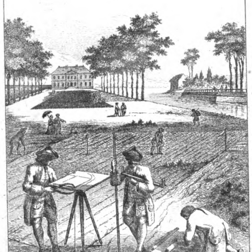
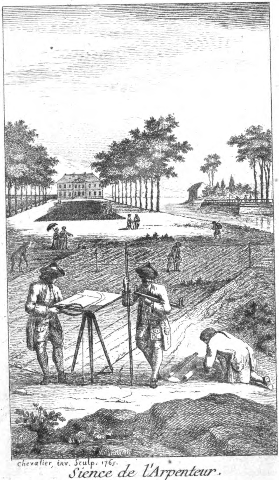
The explosion in the number of large-scale maps in the 18th century was a pivotal moment. As diverse and experimental mapping practices spread rapidly, maps became commonplace. They became essential cognitive artefacts in many social fields. Alongside the engineering drawings that heralded the arrival of scientific cartography, a form of ordinary cartography emerged that clumsily drew inspiration from external models while responding to the new need for graphical representations of space. The increase in demand for maps followed an obscure process. The taste for maps in Enlightenment Europe developed in parallel with, and even preceded, state initiatives. This was particularly evident in private land surveying, which reflected heterogeneous and scattered documentary practices.
This conference forms part of a series of scientific meetings that began in 2025. The first workshop focused on ‘Mapping Literacy and Rural Societies in the 18th and 19th Centuries’. It explored a new historiographical field by examining land plans as an emerging tool for spatial administration. The aim was to examine how these maps were used and integrated into a larger body of existing documentation, such as land registers, tables, lists and inventories. Participants also studied the role of maps in transliteracy practices. The second meeting, scheduled for June 2026, will continue these discussions. Taking a pragmatic approach to the use of maps, inspired by medievalists’ research on the Writing Revolution of the 13th and 14th centuries, proved extremely beneficial. However, attention must also be paid to the peculiarities of the maps, such as the role of visual culture and sensitivity, the diversity of spatial practices, and the importance of mathematical and geometric knowledge. Similarly, land administration practitioners did not belong to a closed social circle. Moreover, their maps had relatively little legal value. For these two reasons, they did not constitute a ‘graphic community’ in the strict sense. Therefore, the genesis of the land plan cannot be considered an autonomous field of research. Rather, this history emerges as the perfect observation ground for the mapping literacy revolution of the 18th century.
It is therefore necessary to examine how professional graphic techniques and cultures circulate among engineers and the ways in which they subtly influence, but also discredit, ordinary cartography (panel 1). Without succumbing to geographical determinism, we will also examine the role of natural spatial configurations and how they are used, such as mountains and the societies that form around them, in relation to land mapping practices (panel 2). We will then study the emergence of maps in the notebooks of scholars and travellers (panel 3). We will conduct a review of current research on the proliferation of cartographic experiments with varying degrees of success that accompanied numerous projects to establish state land tax systems at the turn of the 19th century (panel 4). Finally, discussions will be held on the speed, scale and scope of the revolution in mapping literacy in conjunction with the creation of a heuristic database (panel 5).
The conference will also have a comparative dimension. Most of the panels will focus jointly on the Kingdom of France and the Austrian Habsburg Monarchy. These two administrative monarchies are commensurable, as they were similar in size and population in the 18th century. Both underwent cadastral (Bertier de Sauvigny in 1777; Joseph II in 1784) and topographical (Josephinische Landesaufnahme in 1763) experiments following local, heterogeneous mapping projects. Despite these similarities, the two monarchies remained relatively autonomous with regard to the circulation of state knowledge. Their techno-economic and socio-political frameworks differed significantly: French fiscal centralisation had no equivalent in the lands of the Habsburgs. Other differences included academic structures, property law (Roman law and provincial legal customs vs. differentiated state law), land registration (private notary system vs. public registration), intellectual frameworks (physiocracy vs. cameralism), chancery writing and language (the language of the king vs. linguistic diversity), and pictorial influences. This comparison will therefore enable us to evaluate the importance of the various factors of the cognitive revolution in large-scale cartography, such as fiscal, social and land structures, and the respective influence of printed cartography, visual arts and engineering training.
Bibliography
Antoine Annie et Landais Benjamin (dir.). Cartographier le parcellaire rural dans l’Europe d’Ancien Régime, Presses Universitaires de Rennes, 2024.
Bartos-Elekes Zsombor, „Behind the first Habsburg map of Transylvania – comparative analysis of contemporary manuscript maps”, International Journal of Cartography, 2023, vol. 9/3, p. 507–524.
Baumann, Anette, Karten vor Gericht. Augenscheinkarten der Vormoderne als Beweismittel, Darmstadt: Wissenschaftliche Buchgesellschaft 2022.
Bédouret David, Thémines Jean-François, Glaudel Anne, Genevois Sylvain et Grondin Patricia, « L’imaginaire des élèves en géographie à l’école et au collège », Cybergeo: European Journal of Geography [En ligne], doc. 1023, mis en ligne le 7/7/22, consulté le 11/11/25. http://journals.openedition.org/cybergeo/39252
Bendall Sarah, Maps, Land and Society: a history, with a carto-bibliography of Cambridgeshire estate maps, c. 1600-1836, Cambridge: Cambridge University Press, 1992.
Benedetti Benedetto & alii, Cartography and cadastral maps. Visions from the past for a vision of our future, Pisa, Edizioni della Normale, 2016.
bertrand Paul, Les Écritures ordinaires : sociologie d’un temps de révolution documentaire (entre royaume de France et Empire, 1250-1350), Paris, 2015.
Besse Jean-Marc, Blais Hélène et Surun Isabelle (dir.), Naissances de la géographie moderne (1760-1860) : Lieux, pratiques et formation des savoirs de l’espace, Paris : ENS Éditions, 2010
Binois Grégoire, Les Cartes en mains. Le travail des topographes et la construction de la géographie militaire dans la France du xviiie siècle, Thèse d’histoire moderne, Paris / Strasbourg, Université Paris 1 – Panthéon Sorbonne / Université de Strasbourg, sous la codirection d’Hervé Drévillon et Isabelle Laboulais, soutenue le 12 janvier 2024
Blaut J. M. et Blaut Jim „Notes Toward a THeory of Mapping Behavior”, Children’s Environments Quarterly, vol. 4/4, 1987, p. 27–34.
Bloch Marc, Aakjar Svend, Hall Hubert, Tawney A.-H, Vogel Walther, « Les plans parcellaires : Allemagne, Angleterre, Danemark, France », Annales d’histoire économique et sociale, vol. 1, 1929, p. 60-70.
Blond, Stéphane, L’atlas de Trudaine : pouvoirs, cartes et savoirs techniques au siècle des Lumières, CTHS, 2014
Bloomley Nicholas, « Law, Property, and the Geography of Violence: The Frontier, the Survey, and the Grid ». Annals of the Association of American Geographers, vol. 93, 2003, p. 121–141.
BOURGUET Marie-Noëlle, « A Portable World : The Notebooks of European Travellers (Eighteenth to Nineteenth Centuries) » in Intellectual History Review, 2010, n°20, p. 377-400.
Bret Patrice, « Engineers and Topographical Surveys », in Matthew H. Edney and Mary S. Pedley (dir.), The History of Cartography. Vol. 4. Cartography in the European Enlightenment, Chicago, University of Chicago Press, 2019, Part. 1, p. 383-393.
Brückner Martin, The Social Life of Maps in America, 1750-1860, Chapel Hill : University of North Carolina Press, 2017.
Brunel Ghislain, Guyotjeannin Olivier, Moriceau Jean-Marc (dir.), Terriers et plans-terriers du XIIIe au XVIIIe siècles, Rennes, Presses Universitaires de Rennes, 2002.
Brunner Thomas, « Les sept âges de l’écrit. Les régimes de scripturalité du Douaisis (Ier siècle av. J.‑C. – XIIe siècle de notre ère) », Revue historique, vol. 692, no. 4, 2019, p. 765-831.
Buisseret David (dir.), Monarchs, Ministers, and Maps. The Emergence of Cartography as a Tool of Government in Early Modern Europe, Chicago, University of Chicago Press, 1992;
Buisseret David (dir.), Rural Images: Estate Maps in the Old and New Worlds, Chicago, The University of Chicago Press, 1996.
Byrnes Giselle, Boundary Markers: Land Surveying and the Colonisation of New Zealand, Wellington: Bridget Williams Books, 2001.
Chouquer Gérard, La Terre dans le monde romain : anthropologie, droit, géographie, Paris : Éditions Errance, 2010.
Collignon Beatrice. « Que sait-on des savoirs géographiques vernaculaires ? », Bulletin de l’Association de géographes français, vol. 82, 2005/3, p. 321-331.
Delamotte Éric, Liquète Vincent, Frau-Meigs Divina, 2014, « La translittératie, à la convergence des cultures de l’information : supports, contextes et modalités », Spirale, vol. 53/1, p. 145-156.
Delumeau Isabelle, Le Marin, la Carte et l’Ingénieur : La carte nautique et ses usages (1830-1880), Paris, Sorbonnes Université Presses, 2024.
Desbois, Henri, Les mesures du territoire : aspects techniques, politiques et culturels des mutations de la carte topographique, Villeurbanne, Presses de l’ENSSIB, 2015.
Desrosières Alain, La politique des grands nombres : histoire de la raison statistique, Paris, La Découverte, 2010.
Dumasy-Rabineau Juliette ; Gastaldi Nadine et Serchuk Camille (dir.), Quand les artistes dessinaient les cartes, Paris/New York : Le Passage, AN, 2019.
Dumasy-Rabineau Juliette, Serchuk Camille, Vagnon Emmanuelle, Pour une histoire des cartes locales en Europe au Moyen Âge et à la Renaissance. Roubaix, Le Passage, 2022.
Gaveau Fabien, Propriété, cadastre et usages locaux dans les campagnes françaises (1789-1960). Histoire d’une tension sociale, Besançon, Presses Universitaires de Franche-Comté – Cahiers de la Mshe Ledoux, 2021.
Geertz Clifford, Savoir local, savoir global. Les lieux du savoir, Paris : Presses Universitaires de France, 1986 [1983]
Goody Jack, La raison graphique. La domestication de la pensée sauvage, Paris : Les Éditions de Minuit, 1979 [1977]
Harvey Paul D.A., Manors and Maps in Rural England, from the 10th C. to the 17th, Farnham, Ashgate, 2010.
Hirt Irène, 2009, « Cartographies autochtones. Éléments pour une analyse critique », Espace géographique, vol. 38, n° 2, p. 171-186.
Jacob Christian, Lieux de savoir : Espaces et Communautés, t. 1, Paris, Albin Michel, 2007.
Jaudon Bruno, Les Compoix de Languedoc. Impôt, territoire et société du xive au xviiie siècle, Caen : Bibliothèque d’Histoire rurale, vol. 12, 2014.
Kain Roger J. P., Baigent Elizabeth, The Cadastral Map in the Service of the State. A History of Property Mapping, Chicago/Londres, 1992.
Kent, A. J. et Vujakovic, P., « Cartographic Language: Towards a New Paradigm for Understanding Stylistic Diversity in Topographic Maps”. The Cartographic Journal, 2011, vol. 48/1, p. 21-40..
Laboulais Isabelle (dir.), Les usages des cartes (XVIIe-XIXe siècle) : pour une approche pragmatique des productions cartographiques, Strasbourg : Presses Universitaires de Strasbourg, 2008.
Laboulais Isabelle, « La fabrique des savoirs administratifs », in Stéphane Van Damme (dir.), Histoire des sciences et des savoirs. 1. De la Renaissance aux Lumières, Paris, Seuil, 2015, p. 447‑463.
LABOULAIS Isabelle, « Aux origines de la carte géologique de France : retour sur les productions cartographiques du corps des Mines au cours du premier XIXe siècle », in Les ingénieurs des Mines : cultures, pouvoirs, pratiques. Colloque des 7 et 8 octobre 2010, Paris, Institut de la gestion publique et du développement économique, Comité pour l’histoire économique et financière de la France, 2012, p. 19-31.
Landais Benjamin, « Villages, Actors of Local Cartography? The Cadastral Maps of the Banat (1772-79) », in Liebenberg Elri & alii (dir.), History of Cartography. International Symposium of the ICA, Heidelberg/Berlin, Springer, 2012, p. 129-148.
Landais, Benjamin, « Pratiques proto- ou para-cadastrales ? Cartographies et arpentages seigneuriaux en Hongrie 1750-1790 », in Bullón Concepción Camarero & alii (dir.) Fuentes geohistóricas, nuevas tecnologías, nuevos retos, Santander, Editorial Universidad de Cantabria, 2024, p. 245-258.
Lebeau, Christine. « Regional Exchanges and Patterns of Taxation in Eighteenth Century Europe : the case of the Italian Cadastres », in Holger Nehring & Florian Schui (eds), Global Debates about Taxation, Basingstoke, Palgrave, 2007, p. 21-35.
Long Pamela O., “Trading Zones in Early Modern Europe”, Isis, vol. 106/4, 2015, p. 840-847.
Medyńska-Gulij B. et Żuchowski T. J., „An Analysis of Drawing Techniques used on European Topographic Maps in the Eighteenth Century”. The Cartographic Journal, 2018, vol. 55/4, p. 309-325.
Moriceau Jean-Marc, Brunel Ghislain, Guyotjeannin Olivier (dir.), Terriers et plans-terriers du XIIIe au XVIIIe siècle. Actes du colloque de Paris, 23-25 septembre 1998, Paris, Association d’Histoire des Sociétés rurales et École nationale des Chartes, 2002.
Morsel Joseph, « Le cartulaire de Sigmund I von Thüngen (Franconie, 1448/49) », in Guyotjeannin Olivier et Parisse Michel (dir.), Les Cartulaires, actes de la table ronde de Paris (décembre 1991), Genève et Paris : Droz et Honoré Champion, 1993, p. 411-422.
Mukerji Chandra, « La cognition distribuée en cartographie », in Ambroise Bruno et Chauviré Christiane (dir.), Le mental et le social, Paris, Éditions de l’École des hautes études en sciences sociales, 2013, p. 215-240.
Oesterreicher Wulf, “Verschriftung und Verschriftlichung im Kontext medialer und konzeptioneller Schriftlichkeit“, in Schaffer Ursula (dir.), Schriftlichkeit im frühen Mittelalter, Tübingen, Narr, 1993, p. 267-292.
Ory J., Christophe S., Fabrikant S. I., & Bucher B. “How Do Map Readers Recognize a Topographic Mapping Style?”, The Cartographic Journal, 2015, vol. 52/2, p. 193-203.
Perrat Jean-François, « Organiser un mapathon ou une séance de cartographie participative en classe », Géoconfluences, juin 2018.
Rankovic Slavika, Melve Leidulf et Mundal Else, Along the Oral-Written Continuum. Types of Texts, Relations and their Implications, Turnhout, Brepols, 2010.
Savoy Sébastien. « Des chiffres et des lettres », in Feller Laurent et alii (dir.), Cultures écrites de l’économie aux époques médiévale et moderne, Paris, Éditions de la Sorbonne, 2024, p. 239-26.
Scharr Kurt et Siegl Gehrard, Historische Kataster in Europa. Quellen und Forschungsstand: Jahrbuch für Geschichte des ländlichen Raumes, Innsbruck, Wien, Studien Verlag, Rural History Yearbook 2025.
Scott James C., Seeing Like a State: How Certain Schemes to Improve the Human Condition Have Failed, New Haven/London, Yale University Press, 1998.
Serchuk, Camille, Lies of the Land: Painted Maps in Late Medieval and Early Modern France, Pennsylvania, Penn State University Press, 2025.
Staszak Jean-François, « Ethnogéographie et savoirs géographiques : quelques problèmes méthodologiques et épistémologiques », Bulletin de l’Association de géographes français, vol. 73/1, 1996, p. 39-54.
Touzery Mireille, De l’Estime au cadastre en Europe : l’époque moderne, Paris, Comité pour l’Histoire Économique et Financière de la France, Ministère de l’Économie, des Finances et de l’Emploi, 2007.
Velut Sébastien, « Métamorphoses des cartes en Amérique latine : de Martin Waldseemüller aux cartographies participatives », América, vol. 57/1, 2024, p. 11-27. Verdier Nicolas, La carte avant les cartographes, l’avènement du régime cartographique en France au XVIIIe siècle, Paris, Presses de la Sorbonne, 2015.
